The Green Between
Who We Are
The Portola Garden Club (PGC) is a diverse volunteer group within the Portola Neighborhood Association committed to reimagining overlooked urban spaces along San Bruno Ave into publicly accessible greenspace for people and nature to flourish. PGC welcomes all with mutual respect and an open invitation to help build and maintain the Greenway or to simply explore and enjoy the space.
How to Get Involved
At the Portola Garden Club Volunteer Work Day, you'll have the opportunity to engage in a variety of activities including watering, planting, mulching, weeding, and path maintenance. Whether you're a seasoned gardener or a first-time volunteer, there's a meaningful role for everyone, with tasks suited to all ages, abilities, and skill levels.
Your contribution will make a lasting impact on our community. Bring your work clothes, bring a full water bottle, and come get your hands dirty—we can't wait to see you there! We meet up on the first Saturday of every month at 2 Burrows St from 10am-3pm!
How to Support the Green Between
This dynamic and evolving project is supported by the many volunteers who give their time to building and maintaining the Green Between We depend on grants and the generosity of individuals and organizations for large and small projects alike and the tools to meet our everyday gardening needs.
A donation to the Portola Neighborhood Association supports the PGC and our work to create and maintain community greenspaces.

Photos by Arthur Koch, 2022


Press
Check out these articles about the Greenway and the Garden District:

Greenway looking South from Burrows Pocket Park, 2021
Introduction to the Green Between
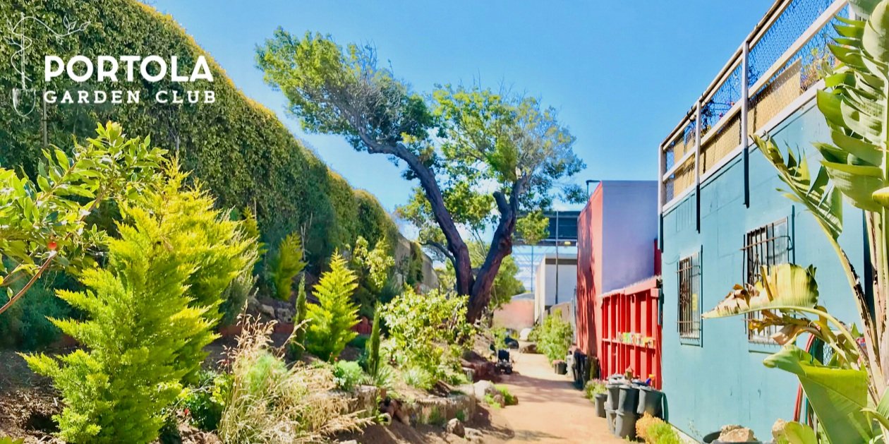
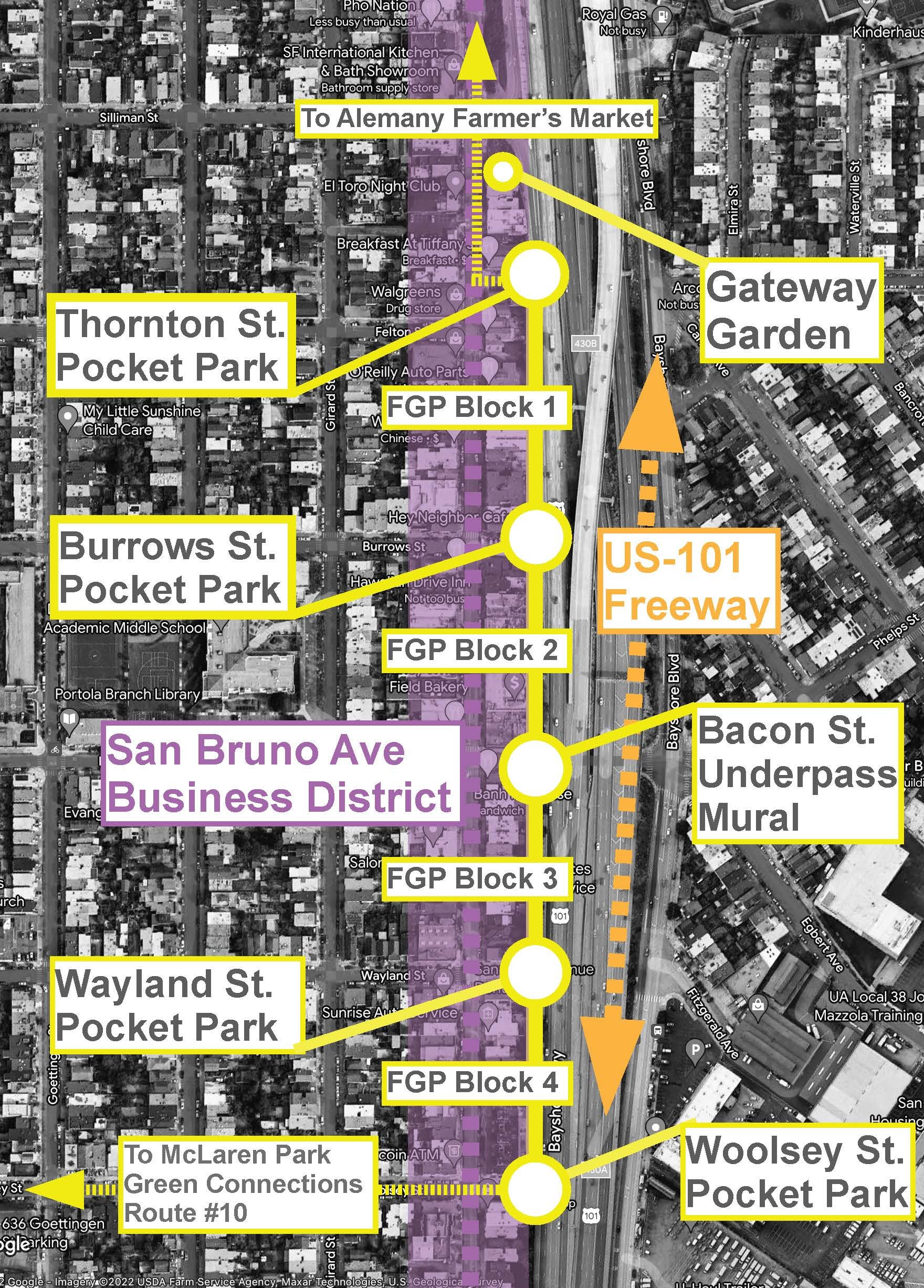
The Portola, San Francisco’s Garden District, continues to march forward in our effort and commitment to ensure a sustainable, healthy, affordable, and inclusive neighborhood. In line with this commitment, the Portola Neighborhood Association (PNA) has partnered with a diverse group of residents and stakeholders to create the Green Between (formerly known as the Freeway Greenway Project, The Greenway/FGP)—the repurposing of an overgrown Caltrans easement located on a sliver of unused land between the West side of US-101 and the backside of the diverse San Bruno Avenue business corridor. In what was a dumping ground for years prior, the PNA is creating a dynamic neighborhood greenway that all members of the community will be able to access.
In collaboration with neighbors who live and work along this strip of unused land, the PNA intends to create a 4 block long multi-use space from Thornton Avenue to Woolsey Street. A volunteer-based project, The Greenway will provide our economically diverse and underserved community an opportunity to find natural tranquility within the layers of movement that have defined this transit corridor for over 100 years.
Extending the Greenway
Explore our recent research on community engagement initiatives set to influence the future aesthetics, ambiance, and activities of the next two blocks of The Green Between. Discover the impact of your voice in action!

Project Studies, Concepts, & Goals
Spurred by the success of Burrows Pocket Park, community members mobilized to study greening opportunities by analyzing the Portola’s unique cultural assets, history, and potential. The Portola Green Plan (published 2015), a multilingual study funded by the city of San Francisco and prepared by SiteLab Urban Studio, was created with the intention of improving public access to nature, as well as providing ecological education and sustainable food sources. The study recommended creating physical, historical, and cultural connections across the neighborhood by means of the Greenway’s creation along with other neighborhood assets to form a cross-community green path from Alemany Farmers Market to McLaren Park, a regional park boasting 313 acres.

Map showing SiteLab’s recommendation for a green path linking Alemany Farmers Market to John McLaren Park through the Portola neighborhood; map credit: Portola Green Plan, 2015
In 2018, SiteLab Urban Studio was hired by The Greenhouse Project and the PNA to conduct a multi-lingual outreach campaign to gather feedback on the first phase of the Greenway, from Burrows Pocket Park south along the Caltrans easement to Bacon St. By means of this study’s findings, along with other community conversations and data collection, the PNA has established the following project goals:
Address the negative impact on safety, beauty, and morale of the community by removing trash and overgrowth in the blighted sliver of Caltrans property not visible or accessible from the freeway.
Create a carbon-capturing natural setting to address community health and mental well-being. The San Bruno Avenue corridor has one of the highest concentrations of particulate pollution and asthma cases in San Francisco and has no green space to offset the effect of the transportation corridor
Convert Caltrans parcels into publicly accessible green space, removed from the noise, pollution, and movement of San Bruno Avenue, for residents and businesses alike
Create an inclusive, durable and unique space, in partnership with existing neighborhood groups, organizations, and businesses, that will be utilized and supported by the diverse community
Provide public outdoor seating for use by business corridor patrons, specifically food and drink purveyors, to directly support the economic growth of the business corridor which largely lacks outdoor seating opportunities.
Provide a unique attraction with space for events, gatherings, and education in order to activate the eastern boundary of the Portola community and business district and reaffirm San Bruno Ave as the community’s “Main Street.”
Enhance gateways along Portola’s eastern boundary and activate neighborhood streets cut off by the freeway, to improve pedestrian access and encourage cultural and physical connections to adjacent communities and amenities.
Rethink the uses of underutilized public land along polluting transit corridors and model how communities can rebound, reclaim, and negate decades of negative cultural, health, and economic impacts.
These 8 goals are in lockstep with San Francisco’s Mayor and Board Of Supervisors (Greenhouse Gas Emissions Ordinance) and Governor Gavin Newsom (SB27), all of who helped enact separate 2021 legislation around nature-based carbon sequestration on public lands. We intend for The Greenway to be San Francisco’s model for conversion of public lands to carbon-sequestering green oases.

Left: Greenway Block 2: 2017 Pre-construction; Right: 2021 Construction
Funding Requirements Past, Present, & Future
Greenway funds received to date:
2012: Burrows Pocket Park hardscape construction: $65,000 Community Challenge Grant awarded to Portola Steering Committee, completed
2016: Portola Welcome Garden & Mural: $64,550 Community Challenge Grant awarded to The Greenhouse Project, completed
2017: Thornton Pocket Park Construction, $135,00 OEWD, underway
2017: Greenway Block 2: Phase I site clearing, $97,750 Community Challenge Grant awarded to The Greenhouse Project, completed
2018-2020: Greenway Block 1: Phase I hardscape construction & Greenplan Coordinator Position: $50,000 MOHCD Grant awarded to The Green House Project, completed
2019: Greenway Block 2: Phase II hardscape elements: $75,000 Community Challenge Grant awarded to the PNA, completed
2020: Greenway Block 2: Phase III landscape elements and plantings: $35,000, The Campbell Foundation grant awarded to the PNA, underway
2021: Greenway Block 2: Phase III landscape elements and plantings: $87,926 Community Challenge Grant awarded to the PNA, underway
2021: Greenway Block 1: Phase I hardscape, plantings, and murals: $91,776 Family Connections Centers, completed
2022: Greenway Block 1: Phase II hardscape, fencing, and plantings: $115,000 OEWD Economic Development Grant, awarded
2022: Greenway Block 2 construction funding: $150,000 Community Challenge Grant, awarded
Estimated Funding to complete & maintain the Greenway:
2022: Portola Green Plan Manager position: $75,000 annually in perpetuity, unsecured funding source
2022: Operating support budget for PNA’s greenspaces: $20,000 annually in perpetuity, unsecured funding source
2024: Caltrans encroachment permits for Greenway Blocks 3 and 4, undetermined budget
2025-2035: Greenway Blocks 3 and 4 Caltrans freeway sound wall, undetermined budget
2025: Greenway Blocks 3 and 4 construction funding: $750,000, unsecured funding source
2026: Wayland St. Pocket Park design, permitting and funding, undetermined budget
2026: Woolsey St. Pocket Park design, permitting and funding, undetermined budget
Status & Timeline
Past milestones marking how we arrived here and where we are going next:
2011 Alemany Island Beautification funded and completed
2014: Burrows Pocket Park funded and completed
2016: Silliman & San Bruno Welcome Garden & Mural, funded and completed
2017: Greenway Block 2: Phase I funded and completed
2018: Green Plan Coordinator funded for 2 years
2019: Greenway Block 1 “Workspace” construction commences
Winter 2022: Funding announcement for Block 1: Final Phase
Spring 2022: Greenway Block 2: Phase II construction commences
Spring 2022: Greenway Community Presentation: Block 1 & 2 Updates
Spring 2022: Funding announcement for Block 2: Final Phase
Summer 2022 - Spring 2023: Construction for Block 2: Final Phase
Fall 2022 - Spring 2023: Greenway Block 1: Final Phase construction commences
Winter/Spring 2023: Greenway Community Meeting: Park Operations
Summer 2023: Greenway Blocks 1 and 2: Ribbon Cutting
Spring 2024: Greenway Blocks 3 and 4: Planning Begins
How Roadways Created the Opportunity
In 1858, what is now the Portola neighborhood of San Francisco, was a largely undeveloped landscape of waterways, rolling hills, and grazing pastures through which stagecoach passengers traveled on the newly beaten path of the San Bruno Toll Road. This unpaved route was created as a shortcut from the historic El Camino Real trail to the booming gold-rush-era downtown San Francisco. To ease this rough and dirty passage, “Mile Houses” were established to serve travelers, marking a century of settlement and growth along this burgeoning transit corridor.
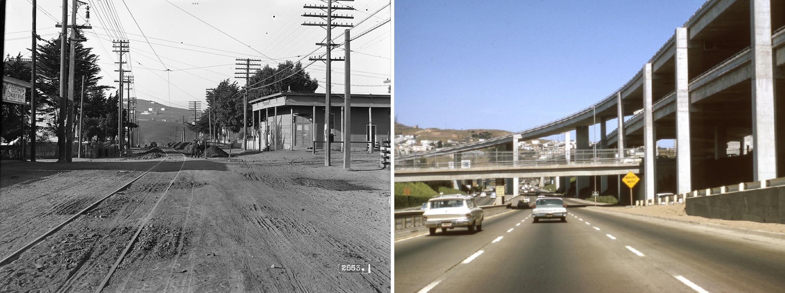
Left: San Bruno Avenue & Silver Avenue, 1911; Right: US-101 & Silver Avenue, 1964 (Photo: Open SF History)
As transportation shifted into the automobile age, the need for expanded roadways increased and in the early-1920’s construction of the four-lane Bayshore Highway began alongside the 2-lane San Bruno Ave, no longer a toll road. This highway linked the city to the growing communities of the peninsula and the parallel alignment of highway to neighborhood mainstreet created a symbiotic relationship in which both streets supported one another’s growth. Fueled in part by a traveler focused service economy, San Bruno Ave, or “The Road” to locals, became the backbone for a thriving immigrant community, which attracted large-scale cultural investments such as the Avenue Theatre, built in 1927.

Old Bayshore Highway looking north near Paul Ave; the new Avenue Theatre can be seen on the left, 1929 (Photo: San Francisco History Center, San Francisco Public Library)
Heavily traveled, undivided and prone to deadly accidents, Bayshore Highway earned a dark reputation as “Bloody Bayshore” and the need for changes quickly became apparent, paving the way for the fully divided and fenced Bayshore Freeway/US-101 in the mid-1950’s.
While this new design greatly reduced traffic deaths and injuries, communities to either side were cut off from their neighbors. The freeway’s new speed friendly design ignored the established urbangrid, creating unusable triangular gaps between the roadway edge and the abutting private properties, formerly the back gardens of San Bruno Ave’s residents. These newly created pockets of land that now belonged to the state were locked in limbo for decades, largely inaccessible for maintenance and inevitably collecting debris and overgrowth.
In the Portola, many structures were razed or relocated through eminent domain and properties that survived on the east-side of San Bruno Ave lost their backyards.

Controversial fencing along Bayshore Highway, 1947 (Photo: Bob Campbell, The Chronicle)
From the 1960s into the 1990s, the community, now bisected and bypassed by the freeway, adjusted to the many challenges felt by disadvantaged urban areas of the time. As new influxes of immigrants and multi-generational families arrived, San Bruno Ave began to serve an increasingly populated and diverse community that stretched beyond the immediate neighborhood. In recent years, the City of San Francisco has upgraded and relocated public transit lines along the corridor, carrying thousands of transit riders up and down the street, many of whom shop and use the services. Despite ongoing economic challenges, today San Bruno Ave is a vibrant albeit sometimes chaotic urban business and public transit corridor, a far cry from its dirt path beginnings.
In the mid-2000s, the emergence of a grassroots movement, centered around Portola’s unique cut-flower agricultural history, began with local residents introducing a series of community-based projects and events to celebrate the neighborhood's agricultural roots. In 2006, the Portola Garden Tour was launched to encourage neighbors and visitors alike to visit one another’s gardens, trade cuttings, and swap growing tips over glasses of lemonade. During the same period, Portola artist team Book + Wheel applied for and received multiple grants to carry out their Portola Cognito Project, where they researched and mapped Portola and adjacent greening agendas future and past, among them the creation of McLaren Park and Daniel Burnham's 1905 green-filled Plan for San Francisco. In 2009, the PNA in partnership with local artists created the Alemany Island Beautification Project to address an overgrown roadway greenspace at the intersection of San Bruno Ave and Alemany Blvd. This project was the first in the community to directly engage with the freeway infrastructure. Utilizing an overpass support column, a mural celebrating San Francisco's native flora and fauna was installed.
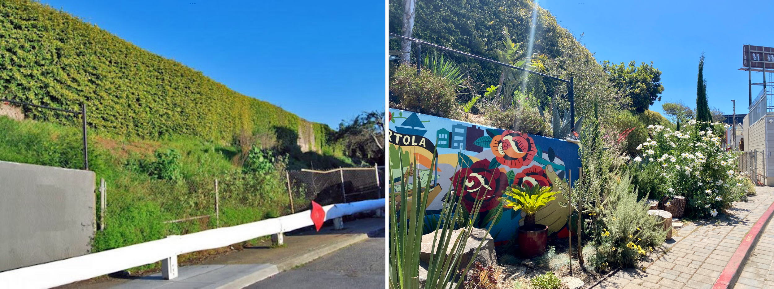
Left: Burrows Street Dead End at US-101 Freeway, 2013; Right: 2021
In 2013 The Greenhouse Project was formed with the intention of saving and transforming Portola’s last greenhouse block, the Rose Factory, into an urban farm and education center. That same year, the Portola Garden Tour, The Greenhouse Project, and the PNA partnered on a pilot project to address another byproduct of the freeway: the blighted dead-end streets along San Bruno Ave. In 2014, after four years of planning and over $200k in public and private fundraising, Burrows Pocket Park was completed, becoming the first greenspace along the Caltrans easement. Today this parkspace, entirely maintained by volunteers, provides community event space just off San Bruno Ave and has attracted a local neighbor to invest in the opening of a cafe.
Greenway Community Connection Concept Map

References:
Portola Green Plan Outreach & Opportunities, published by SiteLab Urban Studios, 2015
When The Bayshore Freeway was the Bay Area’s “Highway of Tomorrow”, Bill Van Niekerken, The San Francisco Chronicle, July 11, 2017
A Historic Line - the Fine 9 San Bruno, Jeremy Menzies, February 18, 2016
Map Shows Which SF Neighborhoods Are Hit Hardest By Air Pollution, Rachel Swan, The San Francisco Chronicle, September 4, 2017
Thank you to our supporters
Our projects are supported by the PNA memberships, donations and funding from the Community Challenge Grant and Shine on SF.


Community Endorsements


